
Question: It the New Britain Track scale in use in my
era? What about the Middletown one?
Answer:
Unfortunately, probably not…

In the March 10,
1941 Office List of Freight Stations, notation #3 indicates: Stations at which
Track Scale is maintained.
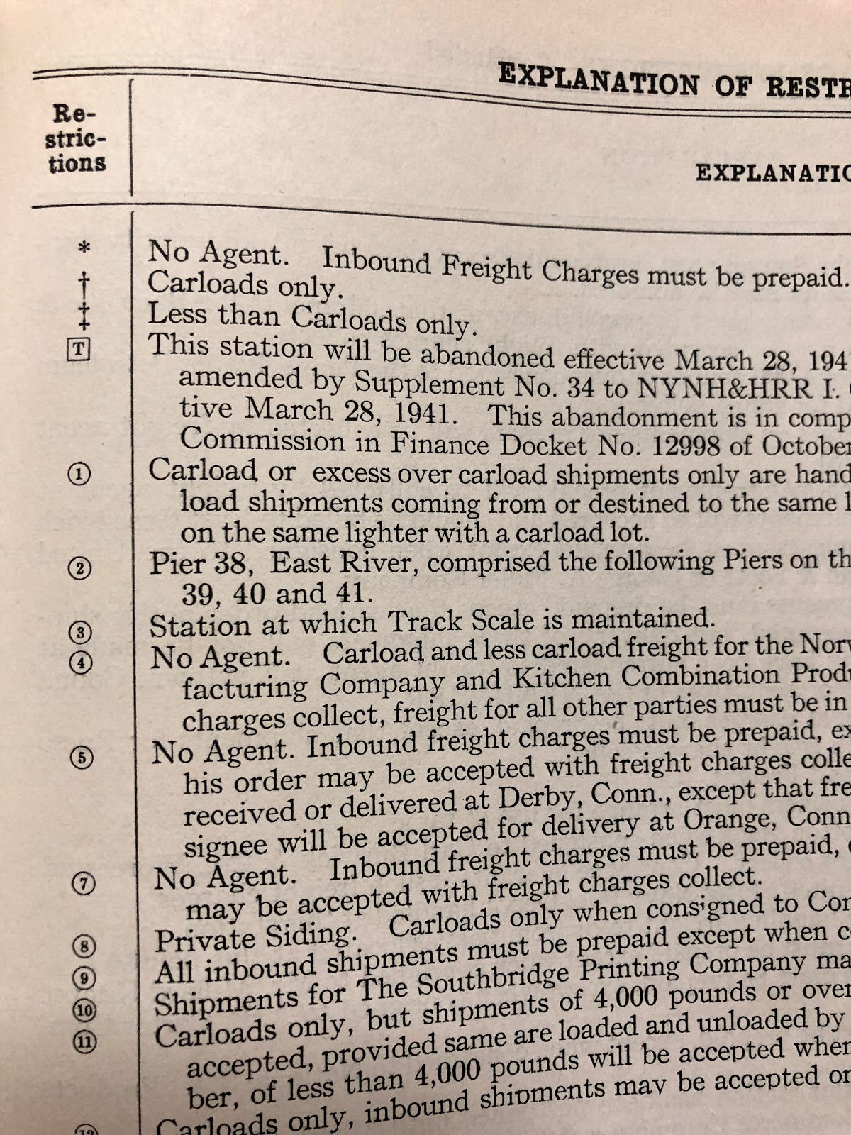
Stations that have
this notation (including their Station No)
70 Harlem River NY
4765 Beacon NY
4985 Poughkeepsie NY
5060 Brewster NY
5145 Maybrook NY
Huh? No Cedar Hill,
Hartford, or Boston?
In fact, no Scale Track listed on the New Haven outside of
NY. That seems odd enough that there may be a reason for that. So I'll have to see if I can confirm this in a later document, just in case the scale tracks were reinstated for WWII traffic, but I doubt it.
I actually don't even have a photo of the Track Scale House in New Britain. We do have one of the Middletown one in a John Wallace photo, so we know it was still there (and Chris has a drawing that indicates when the track was being removed in the '60s if I recall). So I don't know if the track/house is even still present in my era. The aerial photos are inconclusive, the 1951 one shows the runaround is still in place, but maybe not the track scale building or track.
The station numbers, incidentally, were used for routing to/from other railroads. Every state's stations were numbered and this is consistent across the country. So I can look at the N&W or NKP Routing Guide and they list the same station numbers. Also "station" is a technical term on the railroad, meaning "town." Obviously it refers to the freight/passenger stations within a town, but it also designates all traffic to that town.
New Britain is station #3910.
--
In an unrelated subject, Joseph and I were trying to determine what, if any, traffic came to the NH via Westfield. He's a conductor on the Pioneer Valley Railroad, and since I have freights running to Westfield/Holyoke and back, it's also useful information for waybills and traffic on the layout.
The NH Characteristics Charts reprinted by NHRHTA in 1978 includes Density of Freight Traffic maps for 1912 and 1918 (one for 1966 was on eBay recently).
The 1912 one shows 6 trains with 4,076 tons avg daily from Westfield to Simsbury. Between Simsbury and Plainville (with a little math to remove the 2 New Hartford Branch trains) and it's 5 trains, 3,783 tons.
In 1918, it's 8 trains to Simsbury, 7.381 tons, and 6 trains, 10,204 tons. So this would seem to imply a fair amount of traffic could be coming from Westfield, and thus through New Britain.
As I was digging through some things for RPI (they are adding a NYC portion to the layout in their new location), I found this:

A NYC pamphlet that lists New Haven stations and the junction to be used when routing traffic to that station. Inside is a list of the junctions:

1 N&W, Bannon, Ohio (CL), Columbus, Ohio (LCL), NYC (W), North Findley (Mortimer), Ohio, NYC&StL, Buffalo, NY, LV, Jersey City Terminal N. J., Float, Harlem River N. Y., or LV, Easton, PA, L&HR, Maybrook N. Y., NYNH&H.
Note that CL and LCL traffic go through different routings, but it also has two different routings from Buffalo, via Jersey City and car float, or L&HR to Maybrook.
But I digress. The point is, by 1944 and later, it would appear that only the following stations received loads via the B&A/NYC in Westfield:
915 Avon
920 Simsbury
925 Floydville (No agent. Inbound Freight Charges must be prepaid. Private Siding. Carloads only when consigned to Connecticut Tobacco Company). So it appears this was the only industry/siding in town.
930 Granby
935 Congamond (Carloads only.)
940 Southwick
945 Westfield
960 Holyoke
975 Southhampton (Carloads only.)
980 Easthampton
985 Northampton
990 Florence
991 Leeds (Carloads only.)
992 Haydenville
This is helpful, because NY-4/YN-3 is essentially the Westfield local (from Avon and points north, Berlin, and Cremo Brewery in New Britain because it's on the Springfield line just north of Berlin). So I'll have fewer cars to/from those stations on those trains. Staging for this train is 14 cars outbound and 13 inbound.
It was also the train I thought would be bringing cars from Lane's and Cook's quarries for weighing on the track scale. Now it appears that may not be the case. And I might not even need to install the track or the scale house.
It's amazing - and sometimes frustrating - how new discoveries of prototype information inevitably effect layout planning and operations. So I wonder what's gonna happen with that cool Middletown scale house and track now %^)
ReplyDeleteWell, in your case we know it’s still there, even if it’s not in use. I, on the other hand, am on the fence.
ReplyDeleteThe valuation map of Whiting St Yard has parcel updates to 1952, and still has the track scale track there. So I’m probably just going to assume that’s the case, since we know the Middletown one was still there in our era it seems reasonable that the New Britain one is too. It will just have a lot more weeds...