Modeling buddy Jim, who is working on the Springfield Line in N-scale, mentioned he has space on the Berlin Line leg of the wye for an industry. He has a 12" x 100" space to work with, which is about 1,300' long in N-scale if my math is correct. That's a lot to work with...I'll bet we can fill it!
I suggested he look at New Britain Machine Company, an industry I'd love to model but it's south of where the layout ends and I just don't have the space.
The company was another major tool company that was the primary supplier for NAPA until the '60s. This site has an extensive amount of information on the history of the company.
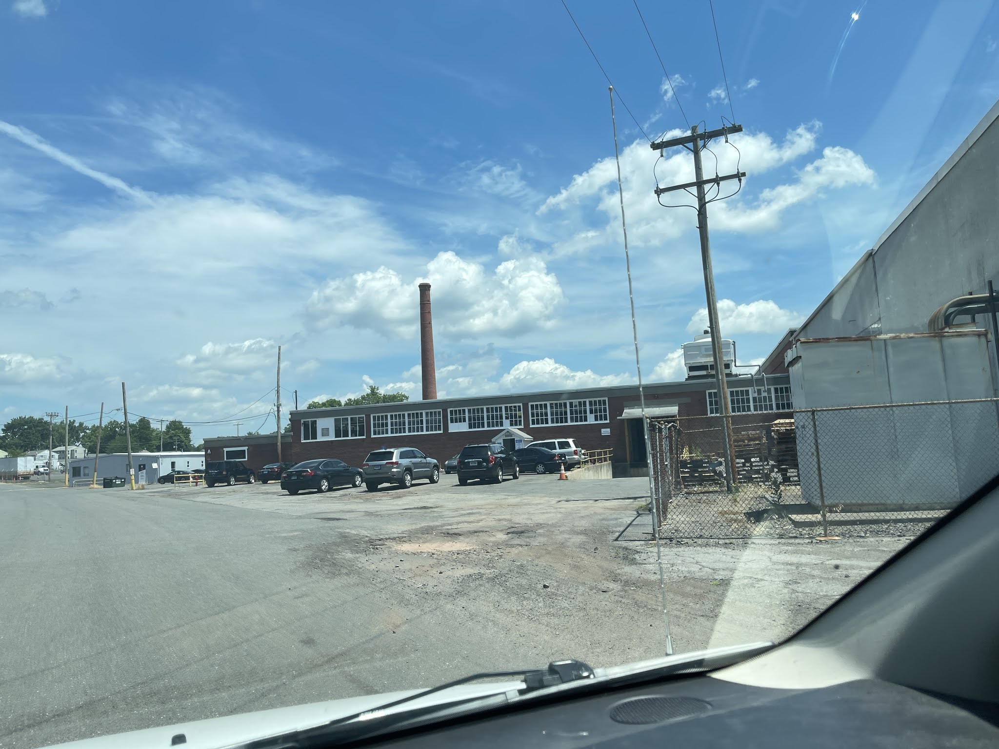
Being a beautiful (but hot!) day, I decided to go take some pictures. Here's a shot of the main building. Two tracks ran along the side, you can make out a couple of rails curving toward it. There's a second major building to the right.
Here are some aerial shots from each direction courtesy of Bing maps. The long, light grey building is the main building. In this first aerial, I would be standing in the lower right for the picture above.
That building is roughly 800' long according to Google Maps. It's about 1000 feet out to the edge of the drive beyond the brick office that is perpendicular to it.
So yes, Jim could model this property to scale. Well, the length, anyway. He has only about 160' in the other direction, and the whole complex is about 800'. But the main building with the drive/tracks is almost exactly 160.'
So there you go, Jim!
Here are the Bing birds-eye views of the other three sides:
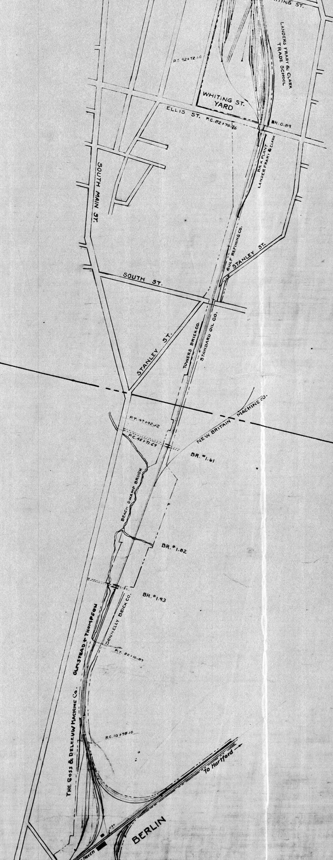
It wasn't present when the original NH valuation maps were created, but it is on this 1940 Alignment Map. It's the track on the right just at the Berlin/New Britain border. You can see it's relation to the Berlin Wye to the south, and Whiting St. Yard to the north.
Sanborn Maps show that it's growing through my era, here's 1950:
And 1954:
Compare that to the Bing Maps aerial:
There are a few sections that are newer than 1954, but not many.
Here's the series I took walking around the complex today.
There are several smaller companies using the property now, but nobody bothered me.
I began walking around the southernmost building.
I had to stop taking pictures because my phone overheated!
After walking around the end, this was the first picture I tried. I still had the overheating warning.
It was far too bright for me to see if the picture had come out, but I had taken it out of the case...
...and it looks like they started coming out OK again. This is at the far end, the peaked roof building (the blurry one in the photo above), is the far end of the main building.
Starting to walk between the two, the main building on my right.
The south building:
A small crane on the main building:
Looking down the main building:
I really liked this very narrow concrete loading dock. This down the length of the main building:
No supports. I think this will work very well on the Landers, building along the back wall of Whiting St Yard.
Although it occurs to me when I look at this picture again:
That it may have been an open loading dock originally, and bricked in later on.
Had I noticed that, I might have taken a closer look here to see what the structure looked like inside.
Looking back the other direction:
Rotating and looking at the south building:
Rotating toward the west.
The main building:
Some rail left in the ground of the second track:
This is the south building, which looked like a hint of where rail might have been, but based on the maps and the rest of the structure and ground I don't believe there was ever a rail here.
Main building:
I'm standing under an overhang on the south building:
Looking down under that overhang at the structure:
Note that the loading "dock" is now fully supported on the main building:
This is the north(ish) side of the main building to the right, plus this newer structure:
Back of the main building (rotating toward the right)
Back of the main building:
Comparing to the Sanborn map, plus just the construction itself, you can see the part with the large door is new here, but the back section is older. The main building is to the right, out of the picture:
On the other side of that newer building we can see some of the older structure again, including the smoke stack:
The back side of that building:
It would be a fun complex to model, even if it's only the primary building that was served by rail. Based on the maps and what I saw today, the side tracks ran the entire length of the building. I love these massive structures, especially if you can model them to scale (or close to it). It helps show the scale of industry in relationship to the railroad.